Monitoring and quantifying the forest degradation in Sri Lanka with open access satellite data
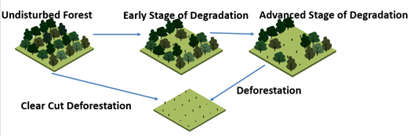
Forest cover is a critical ecosystem component. Deforestation and forest degradation are the biggest threats to forests worldwide. Deforestation occurs when forests are converted to non-forest uses, such as agriculture and road construction etc. Now a day’s Satellite data have been used with varying degrees of success in monitoring of deforestation. But, Degradation is difficult to monitor because when the degradation occurs, the forests functions are getting reduced but the forest still exists.
In relation to the area, degradation of forest is an even bigger problem than deforestation but forest degradation is very often a preliminary stage of deforestation. Therefore identification of the forest degradation is very crucial for better management practices. The major issue here is the reduction in the capacity of a forest to produce very important ecosystem service, carbon storage. A tree absorbs the the atmospheric carbon in the process of photosynthesis but the carbon absorption ability is drastically reduced in the degraded forests. Therefore forest department Sri Lanka requires to categorise the natural forests in to different levels of degradation (highly degraded, moderately degraded, severely degraded) and then to enhance them accordingly to strengthen the Carbon sequestration process of a forest to mitigate global warming. We as space technology applications division, ACCIMT attempts to use open access time series of optical remote sensing data and methods to quantify the degree of degradation of dry zone natural forests in Sri Lanka.